Saturday, February 23, 2013

Valle de la Luna

Our last tour in the desert was to the Valley of the Moon, 13km west of San Pedro. The valley is so-named because its stark landscape resembles the surface of the moon. It is famous for its sweeping sand dunes, salt caves, natural amphithetres and various stone and sand formations which have been carved by wind and water. Our first stop was at the Tres Marias, a natural rock structure which apparently looks like three praying women...

Las Tres Marias (right to left): Maria praying on her knees, Maria holding baby Jesus, Maria destroyed by a tourist

Us in front of the Three Marias

A salty T-Rex!
 
The amphitheatre

The salt road leading out of the Valley of the Moon


We climbed up the Duna Mayor, the highest dune in the valley, for great views over the valley and the Andean peaks and volcanoes.

Tourists climbing the sand dunes

View of the amphitheatre from the top of the dune

The lunar landscape

The Valley of the Moon is considered one of the driest places on earth. On our way out, we stopped at a bright white section of salt. It used to be covered in dirt and sand, but thanks to the freak rain two weeks ago the ground has been cleaned and the salt crystals are gleaming.


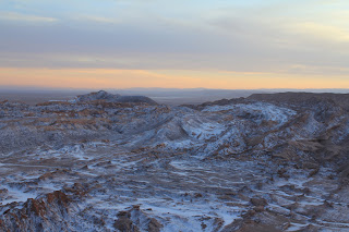
Our last stop was to watch the sunset in the Cordillera de la Sal (salt mountain range). As ever, it was a spectacular blend of colours and a beautiful way to finish off our sightseeing in the desert.

Salt-covered canyons in the desert


Another beautiful desert sunset

Thursday, February 21, 2013

Pukará de Quitor

We walked 3km north of San Pedro to the 12th-century ruins of a fortress. Pukará de Quitor is a red-stone, pre-Incan settlement of the Atacameños (natives of this region) and was built during a period of war. It was taken over by the Incans and then the Spanish settlers. The ruins include defensive walls, terraces, living quarters and pens all connected by passageways.

The old settlement of Pukará de Quitor

The stone walls of the ruins

We also walked up a neighbouring hill in the Cordillera de la Sal (salt mountain range) to a mirador overlooking the ruins, the village of San Pedro, the Valley of the Dead and the Plaza de Quitor.

Rio San Pedro winding its way through Quitor

Salt deposits in the Valley of the Dead

View over the Atacama Desert

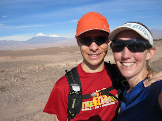
Us at the top of the hill

Wednesday, February 20, 2013

Running in the Desert

Whew! I joined Daniel for a run in the Valley of the Dead on part of the Atacama Crossing race course. The heat, sand and altitude make for a killer combination, even though we were about 245km short of the race distance!

The road to the sand dunes on Stage 2

Me trying to look good...

The sand dunes in sight

Daniel actually looking good!

On the way home with Volcán Licancabur in the background

Lagunas Altiplánicas y Salar de Atacama

We took a tour today to the Salar de Atacamar (salt flat) and the Altiplánico (high plateau). The salt flat is 10km north of San Pedro and lies in a basin surrounded by a circle formed by the Domeyko and Andes mountain ranges. It covers an area of over 3000 square kilometers, making it the largest salt flat in Chile and the third largest in the world.

A path through the harsh salt flat

In the midst of the Salar de Atacama is Laguna Chaxa, a shallow salt lake with volcanic backdrops in all directions, and home to a variety of wildlife, including three species of flamingos.

Laguna Chaxa

Andean flamingos

Chilean flamingos

A flamingo in flight

Some little field mice at the information centre

We left the salt flat for the famous Altiplánico region of the Atacama, which is the high plateau 4000m above sea level. Here we visited Laguna Miscanti and Laguna Miñeques, famous for their birdlife, especially the six species of coots.

Laguna Miñeques

Laguna Miscanti

Our tour ended with stops in Toconao and Socaire, two oasis villages east of San Pedro. These villages use the traditional adobe style of building, securing volcanic stones with a mixture of mud and straw.

The early colonial church in Socaire

Me and a very friendly llama!

Monday, February 18, 2013

Geysers de Tatio

Early on Sunday morning we caught a tour bus at 4:00am and drove 90km north of San Pedro to the Geysers de Tatio. The geothermic basin is the largest in the southern hemisphere and one of the highest in the world at 4,320m above sea level. The geyser field lies in a massive crater and is surrounded by rust-coloured mountains and pointed volcanoes.

Geyser plumes in the crater

The hot magmatic rock of the volcano causes the cold water to boil and steam

El Tatio means 'grandfather' or 'old man crying' in Quechua (natives of northern Chile). It was incredible to see the white vapour streams shoot out of the ground, and to hear the earth groan and grumble and boil and bubble. The geysers were spectacular in the early morning light as the sun rose over the edge of the crater.

Sunrise over the crater

A big geyser

A big spurt of boiling water, about 1m high

The geothermic field

Us in front of a geyser

After viewing the geysers, we warmed up with some hot chocloate which had been boiled in one of the little fumaroles, heated by the 85˚ water from the earth. Thanks Mother Nature! After breakfast we had an opportunity to see the geysers in the full sunlight.


On the way back to San Pedro we passed some small villages, rivers and wetlands. It was strange to see so much water in the desert, and we were lucky enough to see wild vicuñas and llamas in the area.

A wetland in the desert

Wild vicuñas

Vicuña in the wetland

Shaggy llama in the wetland

Mommy and baby llamas!

Funny looking creatures

Laguna Piedra

At sunset we strolled down to another lake in the Laguna Cejar chain, Laguna Piedra. This lake also has a high salt content, but it reserved for the fauna - no humans allowed. The shore is covered in hard salt crystals which sparkle in the sun.


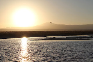
We saw a flamingo, an Andean goose and some little sandpipers around the lake. The flamingo posed for a beautiful flying-off-into-the-sunset picture.


The colours as the sun set were spectacular, as the light played on the salt crystals and picked up on the red sand of the desert. Volcan Licancabur provided a beautiful backdrop for the lake.