Friday, July 31, 2015

Aletsch Glacier

We loved seeing and learning about glaciers in Alaska (Mendenhall; Exit; Whittier) and continued to appreciate them in Chile and now Switzerland. This week we visited the famous Aletsch Glacier, the largest glacier in Europe. It extends 23km through the eastern Bernese Alps in our neighbouring canton of Valais. The whole area, including the glaciers in nearby valleys, was declared a UNESCO World Heritage Site in 2001.

The sweeping glacier

We caught a cable car from Fiesch up to Fiescheralp at an altitude of 2205m. The cable car ascended the mountains in a thick cloud with less than 5m visibility. We were a bit apprehensive that we wouldn't be able to see anything at the top, but the clouds dissipated after an hour of hiking. The first part of hike wound around the Eggishorn to Geltscherstube on a beautiful Alpine trail with wild flowers and waterfalls. There is a 1km tunnel through the mountain to bypass lots of the climbing on this section - we might check that out next time!

Lots of routes from Fiescheralp

Gorgeous streams running down the Alpine trails

As we left the refuge at Gletscherstube we caught a glimpse through a gap in the mountains of a sparkling mound of ice. We rushed closer to see the first breathtaking views of the Aletsch Glacier! We could see all the way up to Concordia, where four large glaciers meet to flow into the main Aletsch Glacier. The clouds had all but disappeared by this stage, and the glacier was framed by crystal clear blue sky. The path runs next to the glacier for quite a while and there are several lovely spots for lunch overlooking the brilliant ice river.

The converging point of four Alpine glaciers

The glacier ends after 23km in the Massa River

Aletschgletscher

Some panoramic photos of the glacier and mountains

The hike down from the glacier was beautiful, winding its way past some mountain lakes, including Blausee and Bettmersee. On one broad ridgetop we were able to see the enormous Monte Rosa peak and the characteristic spike of the Matterhorn in the distance. Down at the resort town of Bettmeralp we caught two cable cars down the mountain and then took a red mountain train from Betten back to Fiesch.


Descending to Bettmersee (lake) and Bettmeralp (town)

Another little red mountain train

A map of our hike

So happy to be at a glacier again!

Wednesday, July 29, 2015

Martigny

We went to Martigny together so that I could explore while Daniel did a training run up the mountain. Daniel's runs begin at the Château de la Bâtiaz and so that is where my adventure began.

Château de la Bâtiaz

The castle takes its name from the Latin word "bastida" meaning fortress or fortified place. It was commissioned by the Bishop of Sion in the thirteenth century and changed hands several times between Sion and the Count of Savoy. It was burnt on 13 November 1475, but the military importance and defensive position of the castle compelled the new bishop to restore it. The château was destroyed again in 1518 and all that remains today is the central building and the tower.

An imposing fortress overlooking Martigny

The central courtyard
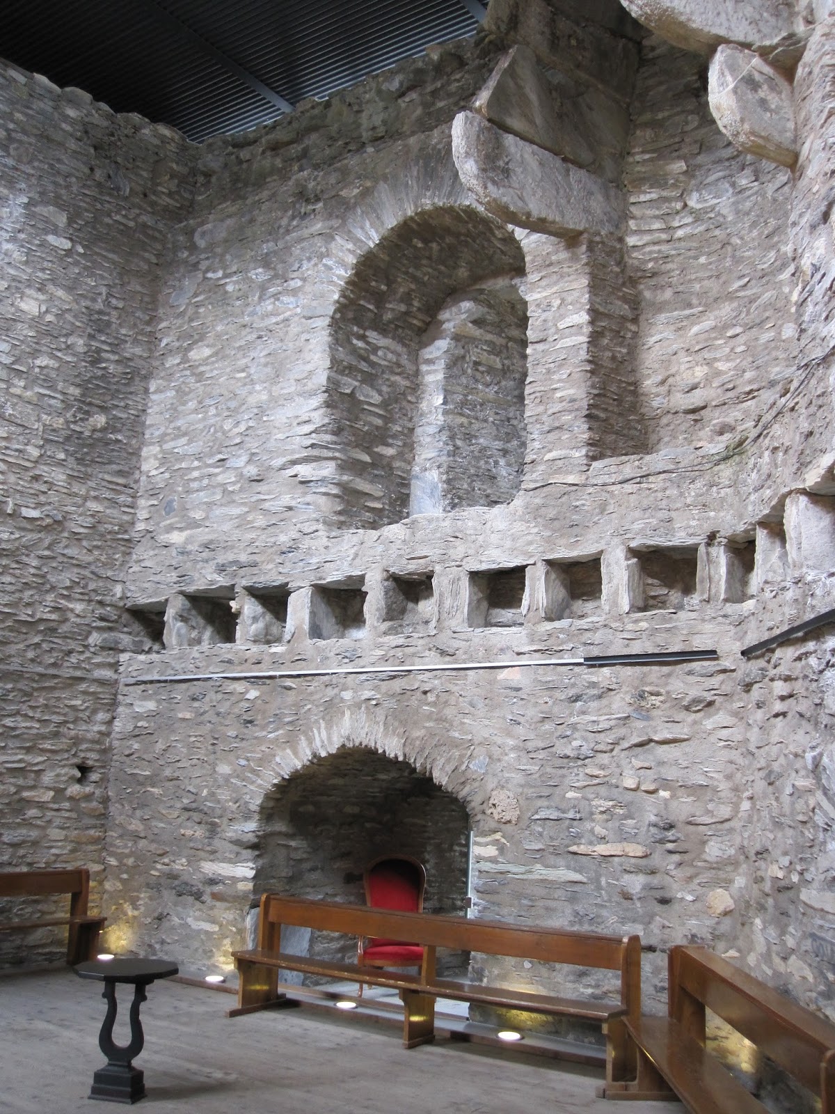
The Hall of Knights

The construction of the tower was taken very seriously and the emphasis was on its defence systems. There are very few windows in the fort, and those which exist are for lookout posts or archers only. The outer courtyard has three trebuchets in it, there is a canon just inside the gate and two other 'war machines' are also on the site. The walls of the tower are 3.5m thick and have a staircase winding up inside. (There are two toilets inside the walls as well!)

The tower rises above the dungeon, which is next door to the torture chamber. The castle sits among picturesque vineyards today, but in the early 16th century those vineyards were gallows. There are 125 steps up to the top of the tower and the views from the top are pretty impressive.

The dungeon, complete with torture instruments and a skeleton

The view from the top of the tower looking up the valley.
Note the terraced vineyards on the slopes of the mountain.

The view down the valley. In the distance there is a wind turbine farm.

Martigny is a gateway town to numerous hiking and skiing trails. After visiting the castle, I followed the little yellow trail signs up through the vineyards and then up and up and up! I walked in the direction of Ravoire, winding up some pretty forest trails.

Lots of options from Martigny

The trail up from the castle through the vineyards

Quiet forest trails

After exploring the mountains, I headed back down to check out the town. Martigny has a population of 15,000 people and it is a bustling town with lots of shops (boutiques and outdoors) and a range of restaurants. The Dranse River flows from the Valais Alps into the Rhone here and there are lovely walks and parks along the river. Martigny has a lot to offer - maybe one day we'll skip the mountains and enjoy the town instead!

An ornate bridge over the Dranse River


Monday, July 27, 2015

Bourg-St-Pierre

We went to the Alpine village of Bourg-St-Pierre in Valais for the Trail du Vélan, a 45km trail race. It's a beautiful village and I enjoyed exploring its secrets while Daniel achieved a top ten finish!

Bourg-St-Pierre is known as the gateway to Italy as it is the last village in Switzerland before the Italian border. It has an important historical tale as it has been the thoroughfare of Hannibal, Roman troops, the Saracens, soldiers and troops of Charlemagne and Napoleon Bonaparte, as well as pilgrims, travellers, smugglers and traders crossing the Alps through the St Bernard's Pass.

The village of Bourg-St-Pierre

The ruins of Chateau du Bourg just outside the village

The Valsorey valley leading towards Italy

Bourg-St-Pierre is also home to Le Moulin du Valsorey, an old mill dating from 1681 which was built along the Valsorey River. The mill was restored and now offers tours throughout the year and a mulled wine party at Christmas. I enjoyed investigating the old mill workings and reading up about the last meunier, Eric Max.

Bridge over the Valsorey River leading to the mill on the left

The old mill house

The mill workings

The region is famous for its rich fauna and flora, and I discovered the La Linnaea Alpine Garden which was opened in 1889. This is a small botanical garden set into the mountains with beautiful little trails and a well-labelled cross-section of Alpine plant species.

Le Jardin Alpin

Daniel's race went well although the conditions were tough at the start. The race began at 4:30am and it was pouring with rain. He headed off in the cold, wet, darkness and emerged a few hours later in 9th place and sunshine!

Running happily towards the finish line in Bourg-St-Pierre

Friday, July 24, 2015

Col du Marchairuz - Mont Tendre (5: Jura)

We've spent a lot time exploring the Jura Mountains in our canton. As we've said before, these mountains stretch from Dielsdorf near Zurich to Nyon in Switzerland, but also extend into France and Germany. It is possible to traverse the Swiss portion of this mountain range on the 310km Jura Crest Trail, the most famous national long-distance trail. The Chemin des Crêtes du Jura or Jura Höhenweg trail is marked with the number 5 route.

The Jura Crest Trail

We've done little bits of this trail (St Cergue; Vallée du Joux; Mont Tendre) and today we completed another 8km section of rolling Jura hills. We followed the number 5 sign from Col du Marchairuz up to the summit at Mont Tendre. More than 60,000km of marked trails criss-cross Switzerland (compared to 72,000km of marked roads!). The Swiss Hiking Foundation is responsible for organising and maintaining the yellow signalisation for the seven national routes, 60 regional trails, and 228 local hikes throughout the country.

The rolling hills of the Jura

No chance of getting lost! We were following the number 5 signs.

Our route today.

Monday, July 20, 2015

St Cergue - La Givrine (5: Jura)

We explored another section of the Jura mountains today, this time catching the trusty red mountain train to St Cergue. St Cergue lies 1000m up in the Jura and is yet another Swiss town with great summer hiking and winter skiing.

The trusty red train

The Sunday market in St Cergue

This time we followed the Chemin de la Dôle trail. La Dôle is the second highest peak in the Swiss Jura (after Mont Tendre) at 1677m. On the summit there is the famous "golf ball", a gigantic white ball containing aviation radar.

Beautiful trails

Our goal: La Dôle summit

Spectacular scenery

View over Lake Geneva and the French Alps

Daniel on the summit with the big white ball

The patchwork of fields between the Jura and Lake Geneva

Looking west along the Jura

Our hike

Apparently Goethe summited La Dôle in 1779 on his way to Geneva and is quoted as saying:"There are no words to describe the grandeur and the beauty of this spectacle." He was right!

Saturday, July 18, 2015

Yvoire, France

In summer there are ferries several times a day across Lac Léman (Lake Geneva) between Switzerland and France. Yesterday we caught the Rhône ferry to Yvoire, a medieval bourg at the tip of the Léman peninsula.

Our ferry - the Rhône

Excited for a trip to France!

The port in Yvoire

Yvoire has been voted one of the most beautiful villages in France. It is a modern fishing village, but remnants of its historical strategic position on the lake can be seen in the castle, ramparts, fortified gateways and houses. It is a charming little village with stone streets, stone walls, abundant flowers, artisanal shops, boutiques and restaurants. We strolled around the village for a while admiring the old stone houses and enjoying the wares in the shops.

A hotel on the lake

Quaint medieval village

Lots of flowers and charm

Cute village streets

Most of the restaurants in Yvoire have fish from the lake on their menus. The most famous is the perch, but there is also arctic char, fera and pike. We went to a restaurant on the lake called "Le Pirate" where we had some delicious perch in garlic sauce and an even better bottle of ice cold wine on a hot day!

A great restaurant by the lake: Le Pirate

On our return to Nyon we took the Valais ferry back across the lake. It was 35 degrees out and the breeze off the lake was most welcome. The trip across to France was a lot of fun and we'll definitely be exploring this area again.

Departing Yvoire

Arriving in Nyon